Review
New Advanced Direction Finding and Geolocation Solution
 10 TIMES MORE ACCURATE THAN A CONVENTIONAL DF 10 TIMES MORE ACCURATE THAN A CONVENTIONAL DF
SHOWS THE DESIRED TARGET ON THE MAP
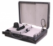
INSTALLATION IN A VEHICLE WITH A CATCHER OR IN A SEPARATE
CHANGE IN VEHICLE SPEED HAS NO EFFECT ON THE ACCURACY
FOR LAW ENFORCEMENT
BORDER SECURITY
DISASTER RECOVERY |  |
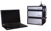
3D-GEO is a state-of-the-art geolocation solution with advanced signal analysis capabilities. It can be used in applications such as surveillance and disaster recovery for locating active cell phones and thereby recovering users.
3D-GEO is designed for vehicular deployments and includes software for determining the exact location of a 2G, 3G or 4G cellular device.
3D-GEO narrows down the transmitter source location to a few meters, highly minimizing the search radius and positively impacting time-critical operations.
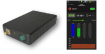
3D-GEO can be controlled over wired Ethernet or Wi-Fi through an easy-to-set-up and user-friendly Windows GUI that provides information such as power measurements, angle of arrival, power, as well as estimated source location overlaid on a map.
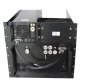
3D-GEO uses custom phased array antennas and advanced algorithms to provide true geolocation capability.
| 3D-GEO gives an estimate of both the azimuth and the elevation of a transmission source overlaid on a standard map. |  |
3D-GEO uses the movement of the vehicle and multiple readings from the phase array antennas to create a heat map that becomes more accurate as more information is gathered.
3D-GEO includes a 3G/LTE UE module for remote management of the unit. It is also possible to deploy multiple 3D-GEO units in different vehicles (connected to the cloud) to improve overall accuracy as well as reduce the operation time.
3D-GEO is a DF that have to be used with IMSI catchers or Active interception systems


 Your basket
 Catalog


 download
 Additional Product Information